Oil spill in Mauritius
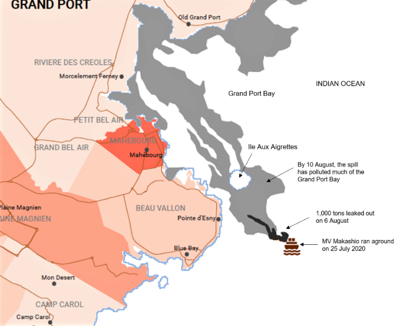
On 25 July 2020, MV Wakashio, a capesize bulk carrier chartered by Mitsui OSK Lines, ran aground a coral reef off the coast of Beau Vallon in the south-eastern part of Mauritius. Though most of the oil has been pumped out of the ship, some 1,000 tons (equivalent to 7,000 barrels) of oil have leaked out on 6 August. By 10 August, the spill has drifted in the north-west direction polluting almost the entire Grand Port Bay (Figure 1).
The Secretariat of the International Society for Mangrove Ecosystems (ISME) at Okinawa, Japan, is very concern over the extensive oil spill and its devastating effects on coastal ecosystems and livelihoods in Mauritius. Its environmental impacts are made worse as important coastal systems (mangroves and coral reefs) and coastal towns (Blue Bay, Pointe d’Esny, Mahébourg, Ferney and Old Grand Port) are located along the southeast coast of Mauritius. Within and adjacent to the disaster zone are the 22-ha Pointe d'Esny Mangrove and the 353-ha Blue Bay Marine Park Ramsar Sites. Affected by the spill are the islands of Ile Aux Aigrettes and Ile Aux Cerfs that generate income from tourism. The marine park is a renowned snorkeling and diving area.
Mangrove and Coral Reef Factsheet
Covering a total land area of 2,040 km2 in the Indian Ocean, Mauritius has a coastline of 322 km (Appadoo, 2003). The island has 1.45 km2 of mangroves (WIO Mangrove Network, 2020) and 300 km2 of fringing coral reefs (Montaggioni and Mahe, 1980). Mangrove trees are 1.5‒3.0 m in height (Fagoonee, 1990) comprising Rhizophora mucronata (dominant species), Bruguiera gymnorhiza and Pemphis acidula (Spalding et al., 2010). The mangrove fern Acrostichum aureum is commonly found in drier more elevated sites.
ISME acknowledges that mangroves and coral reefs are important and environmentally sensitive coastal ecosystems, and that oil spills can lead to mass mortality and other irreversible damage to the environment. The Mauritius government has declared a state of environmental emergency. Assisting the local authorities in the clean-up operations are international organizations from United Nations, France, Japan and India. ISME appreciates such efforts in mitigating the adverse impacts on the coastal environment. Presently, controlling the leak and spread of the oil spill are of utmost importance.
ISME Secretariat, Okinawa, Japan
August 2020
References
- Appadoo, C. (2003). Status of mangroves in Mauritius. Journal of Coastal Development 7(1): 1‒4.
- Fagoonee, I. (1990). Coastal marine ecosystems of Mauritius. Hydrobiologia 203: 55‒62.
- OCHA (2020). Mauritius oil spill extent. Office for the Coordination of Humanitarian Affairs (OCHA) of United Nations.
- Montaggioni, L. & Mahe, J. (1980). Caracterisation faciologique des sediments recifaux de l’ile Maurice par analyse factorielle des correpondances. Oceanologica Acta 3(4): 409-420.
- Spalding, M., Kainuma, M. & Collins, L. (2010). World Atlas of Mangroves. Earthscan, London, UK and Washington, DC, USA.
- Western Indian Ocean Mangrove Network (2020). Mangroves of Mauritius. Retrieved Aug 18, 2020, from http://wiomn.org/mangroves-of-mauritius/